Gamma, the location intelligence company, has agreed a partnership with Ordnance Survey (OS) to deliver the full set of data published by OS through its Perilfinder™ platform. This partnership will allow Gamma to move beyond open data, where greater accuracy is demanded. The full suite of OS datasets will help to enhance Gamma’s risk assessment offering and support its expansion into the UK market.
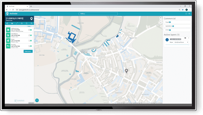
Perilfinder™ is Gamma’s cloud-hosted risk mapping platform, which helps insurance companies reduce their risk profile through sub-second property-level RAG scoring and better management of policy accumulations. The Perilfinder™ v.4.0 platform will incorporate OS’s suite of data, including AddressBase, OS MasterMap, and the OS Open datasets. They will provide Perilfinder™ with the data required to accommodate clients’ accuracy requirements.

With the new addition of highly accurate data from OS, Gamma’s risk assessment and accumulations reporting tool, Perilfinder™, is further equipped to support insurance and financial market users in addressing environmental challenges and understanding their risk exposure.
Speaking about the partnership between Gamma and OS, Richard Garry, Chief Commercial Officer, Gamma, said: “We are delighted to partner with OS to provide a full set of OS datasets to our customers. Gamma has been a keen user of open data and welcomed the OS publication of a much wider set of open data over the summer.
“While open data is of benefit to many of our clients in certain scenarios greater accuracy may be required. Gamma’s customers can now choose between the open dataset and the various commercially available OS datasets, which include building-level data and address geometry and other location information, depending on requirements.”
Stefan Wells, OS Head of Partnerships, says: “We are delighted to have strengthened our partnership with Gamma, and that our data is supporting them in their ambition to develop and grow their business. Up-to-date, accurate location data is the foundation on which government and a variety of businesses rely on to do so much, and we look forward to working with them as they continue to help their clients realise the benefits of this.”
@ 2020 Gammali.co.uk by Monika Ghita
About Gamma Location Intelligence
Gamma is a cloud-hosted solutions provider that integrates software, data and services to help our clients reduce risk through location intelligence. Established in Dublin, Ireland, in 1993, and with offices in Manchester, UK and Bilbao Spain, the company focuses heavily on leading-edge R&D including spatially aware AI and machine learning.
Perilfinder™ v.4.0, Gamma’s risk mapping platform, is a leading-edge property level underwriting solution used by P&C insurers to assess environmental risk. Building on its market leading position across the island of Ireland, Perilfinder™ has recently extended its innovative platform to include the UK through partnerships with the major risk data providers.
About Ordnance Survey
Ordnance Survey is Great Britain’s mapping service for government, business and citizens. Our geospatial data serves the national interest by enabling a safe, healthy and prosperous society. Everything happens somewhere, and every day we support the delivery of efficient public services, support land management and planning, help protect our environment and underpin national security, infrastructure and emergency services. With our partners, we provide expertise and accurate location data and services to help create a resilient nation, ready for next-generation technology. We’re driven to ensure Britain can build a world-leading digital and connected economy of the future.


